© 2000 The Independent Fact Group
![]()
![]()
©
2000 The Independent Fact Group
| Subject: | Trace of an irregular damage in the hull - 2000 |
| Type: | Analysis |
| By: | The Independent Fact Group |
| Status: | Proved |
| Date: | 2000-09-29 |
| Version: | Report: English |
The Fact Group's aims and objectives:
The Independent Fact Group was formed in early 1999 to clear up the many question marks about the M/V Estonia disaster, in a structured and methodical manner. There has been considerable speculation concerning the efforts of the Joint Accident Investigation Commission (JAIC) and the political, legal and media treatment of the accident and its tragic consequences.
The aim is to give those in authority an opportunity, based on the facts of the case, to decide to review this matter, with a view to further action. Our efforts also enable the media and the general public to decide on the basis of the objective information which is available concerning the accident, and the conclusions to be drawn from a technical and civic perspective.
The overall objective is the setting up of a new investigation of the accident which can describe the course of the accident in detail, and its causes, with subsequent assessment of the moral and legal responsibilities, where this is feasible.
We are motivated by the belief that a properly conducted investigation will contribute to maritime safety and by our concern for Sweden's reputation as a nation which upholds safety at sea and the rule of law.
Methodology:
In the course of this task, we have assumed that the solution of a problem is never better than the validity of the basic assumptions. As a result, we have stipulated some methodological principles, of which the following are the most fundamental:
1. All scenarios must be considered to be true until the contrary
is proved.
2. All observations, assumptions or statements on which a scenario
is based must be considered false until the contrary is proved.
We have defined a number of criteria for concluding that an observation, assumption or statement may be considered to be true or false, and processes and routines for the route to be taken in clarifying an observation, assumption or statement. These criteria involve technical, empirical, statistical and/or semantic requirements which, if they are relevant must all be met if the observation, assumption or statement is to be classified as an objective fact.
The materials we have worked with are primarily the documents, audio recordings and films in the Swedish Accident Investigation Commission's Estonia archive, together with supplementary information from other public sources and, in addition documentation from the Meyer shipyard and its independent commission.
Trace of an irregular damage in the hull of M/V Estonia
Summary
In this report the Independent Fact Group analyze the pictures taken during the Bemis expedition August 2000. Members of the diving expedition has claimed that the pictures show evidence of hole in the starboard hull. The analyze is limited to these pictures, but some of the background material showing the present wreck situation, altitude and sand filling around the wreck, has been put together from information in the complete video documentation.
The area of the damage is about 25 meters behind the bow and the pictures show that the visual part of the damage is on the fender. Only a small part of the presumed larger damage is visual, the rest is covered by sand that has been dumped close to and against the wreck. The video recordings made by JAIC 1994 and the Finnish authorities 1996 show that there was no sand around, against or on the wreck at that time. Until 1996 when the last official video recordings were made, the wreck had a list of around 110 degrees starboard. The diving investigation in August 2000 revealed that the ship by unknown reason now has a list of around 125 degrees, and that sand has been dumped around, against and on the wreck at spread locations. In this report we only describe the sand around the area of the damage.
The Independent Fact Group analysis show that the damage is a hole in the large fender that runs along the side of the ship in the level of the car deck. The height above normal waterline is around two meters. Only a very small part of the damage, 0,1 meter, is visual. It is therefore not possible to make any conclusion of the total damage on the hull as it is covered by sand. It is however clear that the sand has sunk forming a crater that expose the damage. No scratch marks can be seen around the damage or along the fender why it seams unreasonable that the damage is a result from a collision with a pier.
Wreck situation 1994 - 1996 compared to 2000
The pictures from the expedition clearly shows that the wreck has altered its position since 1994 and 1996. Seen from "straight ahead" the wreck now lists about 125 degrees starboard compared with the earlier listing around 110 degrees. It has resulted in a shift of the mudline for the wreck. The starboard forward upper corner of the hull, where the hull side meet with the front bulkhead (A in picture 1 and 2 below) was about 4 meters above the seabed in 1994 and 1996. We shall mention that members of the Bemis expedition has stated that the present situation is that the wreck rests almost up side down. We have however not been able to verify other than a 125 degrees list according to the video recordings from the expedition.
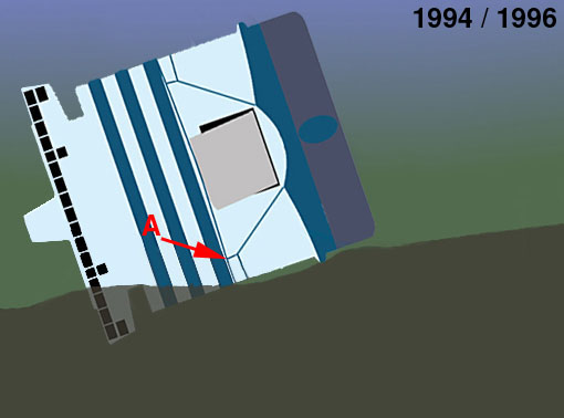
Picture 1. The wreck on the seabed in 1994 and 1996. Starboard list around 110°. A indicates the forward starboard upper corner of the front bulkhead where the visor was attached. Distance from this point to the seabed was around 4 meters.
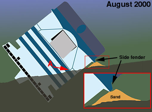
Picture 2. The wreck on the seabed in August 2000. The starboard list has changed to around 125°. The hull at the same point A is now in the mudline level, some 4 meters closer to the seabed. A pile of sand has been dumped close to the starboard fender up to the level of the same.
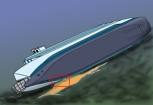
Picture 3. Overview of the wreck seen from the bottom side. The the bow area to the left in the picture. The marked red area show where the sand has been dumped and where the diving team has claimed that evidence of a hole in the hull was found. The red area correspond to the mosaic area in picture 4 below.
Analyzed area of the ship
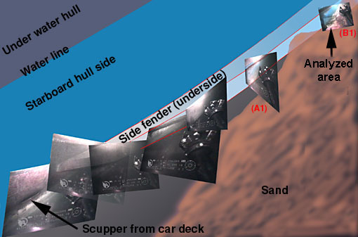
Picture 4. A mosaic with pictures from the Bemis video 29 August 2000 at around 15.40. Along both sides of the hull a large fender runs as a part of the hull construction. The fender is around 0,5 meter wide and of about the same height. The Independent Fact Group has without success asked the German Group of Experts (that represent the shipyard that built Estonia) for construction drawings to be able to conclude the detalied fender construction. In the picture the fender can be identified just close to a scupper from the cardeck. This is where the fender begins in the forward part of the ship. In this picture the location of the analyzed area is in the upper right corner, where the pictures of the supposed hole area was recorded.
Picture 5. Note: The video pictures are up side down in relation
to the normal ship (before the disaster).
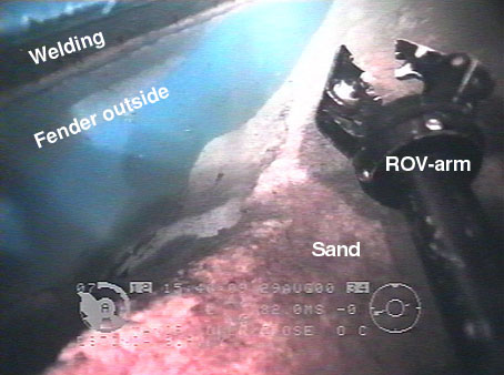
This picture correspond with B1 in the mosaic above. From the
top in this picture, the lower welding on the outer part of the
fender can be seen. The blue area is the outside of the fender,
in reality the part of the fender that is parallel to the hull
side. This is also the part of the fender that was the contact
area to the pier in harbors. It is not unusual that the fender
on a ship is damaged from hard contacts with the pier. Such damage
has not been found in the area that have been analyzed. To the
right in the picture the "grip arm" on the ROV. In the
lower bottom part of the picture there is sand that has been filled
up against the hull side covering a part of the fender. Do also
note that the light on the ROV project shadows from the right
to the left in the picture, clearly seen by the shadow from the
grip arm.
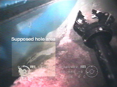
Picture 6. The area on the fender that is to be analyzed has been marked and changed in contrast.
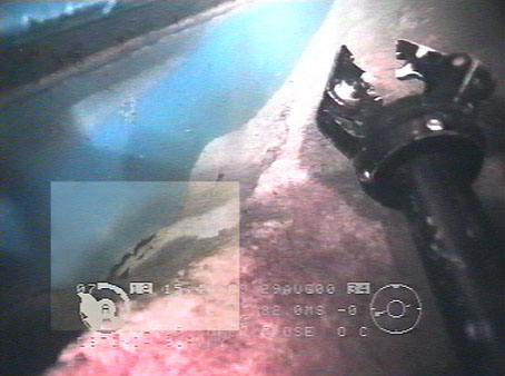
Picture 7. The area has then been changed in colors, intensity, contrast and sharpness in different levels. The rest of the picture is left in "original" quality. The irregularity of an edge in the fender plating can be seen more clearly. A shadow is cast with the same irregularity and "profile" as the edge against what must be the inside of the (broken) fender or any object inside the fender.
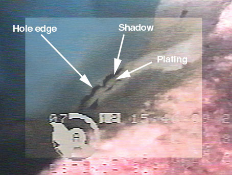
Picture 8. Enlargement where a "hole edge" has been traced. The "edge" clearly cast a shadow against the plating that can be seen in the "hole". The hole is in the outer part of the fender and (in the picture) higher up than the "next welding" on the fender that is hidden in the sand. Possibly the hole continues down (in the picture) i.e. up on the plating of the fender that is a part of the hull side. If that is the case this can be the place where there is a larger hole in the ship hull in to the cardeck. As the fender is positioned just below the cardeck level it is possible that such a hole also opens down below the cardeck into deck 1.
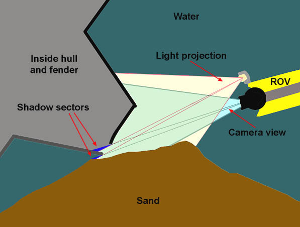
Picture 9. This picture show the theoretical effect of light and view produced during the video recordings. The light on the ROV enlightens the hull from a slight different (higher) angle than what can be seen from the camera view. The effect is projected shadows illustrated by the blue "shadow sectors" in the picture. The first sector cast a shadow somewhere inside the fender or hull, while the second sector cast a shadow under the fender. This picture is not meant to correspond with the video recordings, only to show the theoretical effect to make the analyze more illustrative.
In the following pictures we have compared the relative angle between the lower and upper longitudinal weldings on the outer side of the fender. This comparison can only serve as an indicator, to see if the plating seen in picture 8 correspond or not with the relative angle between the weldings.
It is of course important for such an indication that the ROV continues the filming with the "same" perspective in relation to the hull side. As seen in the video and the mosaic the pictures A and B is recorded just a couple of meters apart. The ROV continues along this section in a very stable condition with almost no change of the perspective.
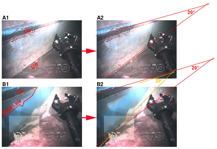
Picture 10. A comparison between two pictures of the fender. The
location of the pictures can be seen in the mosaic (picture 4).
From the picture 10-A1 the fender can be identified where both the lower (LW) and upper welding (UW) can be seen. In this location the sand is not filled up to the level of the fender, why it was easy to determine where the two longitudinal weldings were situated.
In picture 10-A2 the perspective is lined out forming an angle of 20° between the weldings.
In picture 10-B1, where the hole in the fender is, the sand has been filled up to partly cover the fender. At the specific point of the hole, the sand seem to have sunk down exposing the hole in the fender. It can also concluded how much of the fender that earlier was covered by sand as the "Sand Line" can be seen, compare picture 10-B1 and 10-B2. The surface of the fender that was covered by sand is almost "clean" without sediment, while parts of the hull that has not been covered show a gray layer of sediment. Compare also picture 10-A1 and 10-A2.
In picture 10-B2 the perspective with an angle of 20° is lined out to check if it correspond with the "angle of the hole edge". As seen in this picture the perspective does not fit. The edge of the hole or the plating seen in the hole does not correspond with the supposed angle of 20° in the perspective, but with some 29° indicating that the "hole edge" and "plating" is not mistaken to be the "upper welding". Also compare with picture 8.
Conclusion
There is a clear edge forming an irregular part of a hole in the fender.
The hole is close to the upper welding of the outside plating of the fender.
Beyond all reasonable doubt there is a hole in the fender. Without further diving investigations and removal of the pile of sand, it is not possible to conclusively say anything about the size of the hole. The hole most likely continues up on the fender and could also be larger continuing up on the hull side (cardeck level).
Regarding the sand fill, it must have been performed after June 1996. The main reason for that is the shifting of the wrecks position on the seabed. As shown in picture 1 and 2 the fender and hull side close to the fender has distanced itself from the seabed. Therefore the sand can not have been there before the shift of position.