© 2001 The Independent Fact Group
![]()
![]()
©
2001 The Independent Fact Group
| Subject: | M/V Estonia - the last voyage |
| Type: | Partial status report |
| By: | The Independent Fact Group |
| Status: | Proved |
| Date: | 2001-02-11 |
| Version: | English |
The Fact Group's aims and objectives:
The Independent Fact Group was formed in early 1999 to clear up the many question marks about the M/V Estonia disaster, in a structured and methodical manner. There has been considerable speculation concerning the efforts of the Joint Accident Investigation Commission (JAIC) and the political, legal and media treatment of the accident and its tragic consequences.
The aim is to give those in authority an opportunity, based on the facts of the case, to decide to review this matter, with a view to further action. Our efforts also enable the media and the general public to decide on the basis of the objective information which is available concerning the accident, and the conclusions to be drawn from a technical and civic perspective.
The overall objective is the setting up of a new investigation of the accident which can describe the course of the accident in detail, and its causes, with subsequent assessment of the moral and legal responsibilities, where this is feasible.
We are motivated by the belief that a properly conducted investigation will contribute to maritime safety and by our concern for Sweden's reputation as a nation which upholds safety at sea and the rule of law.
Methodology:
In the course of this task, we have assumed that the solution of a problem is never better than the validity of the basic assumptions. As a result, we have stipulated some methodological principles, of which the following are the most fundamental:
1. All scenarios must be considered to be true until the contrary
is proved.
2. All observations, assumptions or statements on which a scenario
is based must be considered false until the contrary is proved.
We have defined a number of criteria for concluding that an observation, assumption or statement may be considered to be true or false, and processes and routines for the route to be taken in clarifying an observation, assumption or statement. These criteria involve technical, empirical, statistical and/or semantic requirements which, if they are relevant must all be met if the observation, assumption or statement is to be classified as an objective fact.
The materials we have worked with are primarily the documents, audio recordings and films in the Swedish Accident Investigation Commission's Estonia archive, together with supplementary information from other public sources and, in addition documentation from the Meyer shipyard and its independent commission.
Contents:
This report - "Partial status report"
Background to the report
-Witnesses
JAIC (the Commission) and the GGE (the German Group of Experts)
-What makes the "JAIC and GGE route" impossible?
Time of departure and the voyage, the different versions according to JAIC
-The Departure time
-Statements from the crew - departure time
-Statements from the passengers - departure time
-Summary regarding the departure time
-The Fact Group conclusion regarding the departure time
Futher evidence and report procedure
-Example Silja Europa
-Example Mariella
-Specific Estonia evidence
-Overview - M/V Estonia - the last voyage
The unidentified ships versus M/V Estonia
-The Finnish printout of "all passenger traffic" 27.09.94 called 'Estonia' 1758 40H.
-UTC versus Local Time
-The Fact Group plot of the "Unidentified ships"
The last M/V Estonia voyage
-Input values for the route (in Estonian time)
-The Fact Group Conclusion on the last M/V Estonia voyage
DEDICATION
This report - "Partial status report"
This report is what we have chosen to call a "partial status report". In that respect the report is different from earlier reports. The reason for the change of format is that the subject is so extensive that it can not be presented in the one and same report. This report- "the last voyage" therefore focus on the first part of the voyage. The second part and the detailed route at the accident site will be covered either in a following report covering the sinking and the rescue operation, or our material regarding this will be handed over to a new independent international investigation group.
The aim with this report is to show that the route concluded by JAIC is incorrect. The JAIC route was used to support their scenario on how M/V Estonia could loose her visor. This report will reveal the sloppy investigation work performed by JAIC and further more call for a new investigation of the disaster.
Background to the report
The information and conclusions in this report is based on collection of material from a number of sources, such as the Joint Accident Investigation Commission (JAIC), the German Group of Experts representing the Meyer Ship Yard (GGE), the archives at Swedish Board of Accident Investigation (SHK), Swedish National Maritime Administration (SNMA), as well as other independent information and witness statements.
The main information consists of a number of plots made by the Finnish Coastal Surveillance carried out from different radar stations. One of the main stations is the Utö Fort Radar Station. According to the Finnish Coastal Surveillance 98.11.03 (195 K pdf) the situation 28.09.94 at 01.30 was the following: M/S Estonia was from the time she left Tallinn in the Finnish Radar surveillance area together with the other ships; M/S Silja Europa, M/S Silja Symphony, M/S Mariella, GTS Finnjet, M/S Finnhansa, M/S Isabella. M/S Estonia disappeared from the Utö Fort Radar at 01.48.
The plots have not been analyzed by JAIC or other parties. Without any fact JAIC concluded the last voyage on a number of assumptions, such as departure time, route and speed. They didn't even bother to interrogate the second M/V Estonia crew to determine the normal route for the ship. As to the weather situation they assumed it to be worse than their own investigation proved, something that did not stop them from stating that the weather situation was extreme during the last voyage.
From various sources, not used in this report as evidence, we have got information that M/V Estonia's normal route from Tallinn was through the north exit, not through the west bound exit as JAIC assumed. After leaving the north exit a north west course was set to join the other ships in the traffic separation zone, following the same in an almost westerly course. The reason was mainly a safety matter as they then followed the zone together with the other ships and thereby they never had to cross the traffic zone in mid night and unfavorable angle (not permitted/recommended). But it is also true that M/V Estonia used two alternative routs, one called the "South route" and one called the "North route". See the following picture.
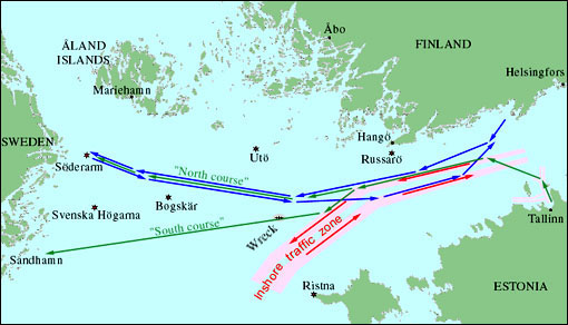
Picture 1. The both M/V Estonia routes (green arrows) had in common the north exit in and out from Tallinn. Both routes also followed the traffic separation zone and the other ships (blue and red arrows) in the Gulf of Finland. The South route was heading for Stockholm via Sandhamn, and the North route also heading for Stockholm was via the north entry at Söderarm. When M/V Estonia on route from Tallinn should use the South route they had to alter the course to avoid meeting the fleet from Stockholm to Finland in a small and dangerous angle. Therefore they followed the traffic separation zone to the south (south west of Hangö) before changing course towards Sandhamn.
In 1998 GGE interviewed the the former Captain on Silja Europe, Esa Mäkela, the officer Seppelin (former officer on Silja Europa) and the former Captain on Mariella, Jan Thore Thörnroos. From this interview (204 K) it is clear that Estonia used to "come up from the south east" and then accompany Silja Europe and Mariella on the route towards Stockholm. In the same interview some detailed information regarding the two different crews at M/V Estonia are reveled. The two regular crews altered on board the M/V Estonia after every 14-day duty period, and both used the same route to and from Tallinn. Leaving Tallinn for Stockholm they reached the joining point just outside Porkkala fairway from Helsinki (Helsingfors) at about the same time as Silja Europe entered the traffic zone. However one of the captains on M/V Estonia whenever the opportunity was given, passed in to the zone close and in front of Silja Europe causing them to reduce the speed. The other captain however always followed the regulations joining to the westerly course behind Silja Europe.
Witnesses
Beside of the statement from the crew on Mariella Ingmar Eklund, there are only two witnesses that have given any information regarding the route. It is the crew member and survivor Einar Kuuk on Estonia that was on board for the first time as a trainee, and secondly it is the passenger and survivor Anders Ericson that during the evening visited the bridge around 20.00 Swedish time (not Estonian time as referred to by JAIC and GGE).
Apart from the official statements used by JAIC, there is one very important statement from the survivor Rolf Sörman, who saw Mariella during the evening at very close distance.
The detailed information given from the witnesses will be described in the following reconstruction.
JAIC (the Commission) and the GGE (the German Group of Experts)
Regarding M/V Estonia's last voyage both JAIC and GGE has come to almost the same conclusion. The route is identical and differs only in minor details and minutes. For example they do not believe in the same departure time. JAIC concludes the departure time to be 19.15 to 19.25 depending on which of the 4 different JAIC versions one read.
The GGE (chapter 19 in their report) concludes the departure time to be 19.15 to 19.30, mainly based on the witness statement of Bengt Nilsson. According to GGE this statement was the main information for JAIC to conclude the departure time. According to GGE has Nilsson testified as follows: "The vessel left the berth when they entered the restaurant, thus it must have been 19.30 or later, because the restaurant only opens at 19.30."
It is interesting to note that Bengt Nilsson in fact states something else in the only official testimony he has given (SHK Estonia D 34:123) from the 4 October 1994. He states the following:
"Nilsson says, that when he met his friends and they talk about who should go [to the restaurant] to have some 'smörgåsbord', the ship had not yet left the harbor/pier. He believes that the ship left just after that. He further tells, that some of them went [to the restaurant] and booked for the 'smörgåsbord', and that they got |tickets for] the session between 19.00 and 21.00 or 21.30 hours."
Later in the testimony he says: "When they went to the restaurant, the ship left the pier." Unfortunately he does not say what time it was at that point.
It is not possible from his testimony to conclude anything about the exact time of departure. The statement from GGE referring the testimony by Nilsson is not correct, as in fact Nilsson says that they got the session between 19.00 and..., so how could the restaurant only open at 19.30 as referred by GGE?
The GGE in their report chapter 20, discuss the different alternatives
of route that they have found. The alternatives are:
1. The JAIC course
2. A course based on a Navy chart found in the Swedish prosecutor
Tomas Lindstrand's files
3. A north course leaving north the Island Nayssaar
Regarding alternative 2, GGE says as follows: "Nevertheless, it has to be mentioned that in the files of the public prosecutor Tomas Lindstrand [Sweden] the copy of a navy chart was found which indicates that ESTONIA took a course of about 270° true from the end of the Traffic-Separation-Scheme (TSS) between the mainland and the Island Nayssaar straight up to Söderarm. This could have been realistic since it was known from the beginning that she had to enter the archipelago Söderarm because of the pilot examination of Captain Avo Piht. Therefore it would actually not have been necessary first to go down to the waypoint and then go up to the North again. On the other hand, it could also be argued that sailing as long as possible in the shelter of the Estonian North coast would be for the comfort of the passengers, although evidently this was the last thing Arvo Andresson cared about."
The Fact Group commentary:
We find it remarkable that GGE refer to what Captain Arvo Andresson cared about, using it as an input for the reliability of the presumed route. As what we know, Captain Andresson never came back from this fatal journey. Furthermore, up to our knowledge, it has newer been confirmed that M/V Estonia really was on her way to Söderarm. And even if she was, it has never been confirmed if there was a change of plan, misunderstanding on the bridge, or change of course of some other reason.
Regarding alternative 3, GGE says as follows: "According to the Finnish Navy, however, ESTONIA took with circa 90% probability a completely different route. Allegedly after having crossed the TSS north of Nayssaar she did follow the westbound lane along the Finnish coast, but subsequently altered course to the south-west. In the opinion of this 'Group of Experts' this is the less likely version because it is the longest distance and simply impossible for ESTONIA to pass within the time available."
Comments by the Fact Group:
We find it the same as remarkable that GGE concludes this alternative to be impossible. It proves that they never checked if that was the case.
Both JAIC and GGE has concluded the route on a few witnesses without checking if their conclusions stand a closer scrutinize. They both came the conclusion that Estonia left Tallinn via the west exit south of the Island Nayssaar and thereafter proceeded on course 262° down to the last way point. It will be shown here that their conclusions are incorrect, and following that it opens for an interesting question, namely: Why did neither JAIC or GGE see that?
What makes the "JAIC and GGE route" impossible?
A few statements definitely show that their conclusion is incorrect.
1. The mate on Mariella, Ingmar Eklund, states that he saw Estonia all night on the radar [from 22.00 hours]. The radar was set to view 15 nautical miles. At 22.00 hours Eklund saw [visually] Estonia 30° on the left side of Mariella and closer than Silja Europa that he saw further away on the starboard side. How close was Silja Europa at 22.00? Answer, she was only 3 nautical miles away! Estonia was subsequently closer. According to the JAIC and GGE route Estonia was at this point at least 15 nautical miles away. We say" at least" as they did not report the position of Mariella at this time.
According to the JAIC/GGE route, it is not even sure that Estonia was as close as the 15 nautical miles Eklund had his radar set on, and further more, if Eklund saw Estonia at this point, he should have seen her at around 60° on the starboard side, and definitely not closer than Silja Europa. Eklund also states that he saw Estonia visually several times during the night using binoculars. It would not be possible to see and identify a ship on 15 nautical miles.
2. Both JAIC and GGE use the the statement from the mate Einar Kuuk on Estonia to confirm the way point that Estonia should have used at around 00.30 [GGE 00.20]. However both "forget" that Kuuk also states that "after 21.00 [when both captains entered the bridge] they had been on the route towards the way point for 20 minutes". Checking this information with the JAIC and GGE route they should after 21.00 have been on that route for more than one hour, not 20 minutes, as the way point at Suurupi 1 was the only earlier way point where Estonia passed just before 20.00.
Time of departure and the voyage, the different versions according to the Commission
Version 1: JAIC final report: CHAPTER 1 THE ACCIDENT
"The Estonian-flagged ro-ro passenger ferry ESTONIA (Figure 1.1) departed from Tallinn, the capital of Estonia, on 27 September 1994 at 1915 hours for a scheduled voyage to Stockholm, the capital of Sweden (Figure 1.2). She carried 989 people, 803 of whom were passengers. Figure 1.1 The ro-ro passenger ferry ESTONIA. Figure 1.2 The ESTONIAs route and the site of the accident. The ship left harbor with all four main engines running. When she was clear of the harbor area full service speed was set. The engine setting was maintained up to the accident. The wind was southerly, 8-10 m/s. Visibility was good, with rain showers."
Version 2: JAIC final report: 5.5 Speed
"There are no recordings of the speed of the ESTONIA during her voyage from the harbor in Tallinn to the time of the accident.
The Commission has made an estimation of how the speed was affected by the waves, inter alia by comparing her speed with the speed of the SILJA EUROPA, another passenger ferry steering a nearly parallel course about eight nautical miles north of the track of the ESTONIA. Other available observations have also been used in the estimations. The speed of the SILJA EUROPA is taken from the DGPS recording which 30 times/minute registers the position, the time, the speed over ground, the course over ground and the heading. The data reveal how the speed was affected by the wind and waves.
The ESTONIA departed from Tallinn 15 minutes late from her normal schedule. The manoeuvre from the port to the Tallinn leading lights is estimated to have taken about 10 minutes. It must be assumed that full service speed, i.e. about 19 knots, was maintained from the Tallinn breakwater to Osmussaar lighthouse, which she passed very close at 2200 hrs. Her estimated speed was still close to 19 knots and she was now a few minutes ahead of normal schedule.
Between 2215 and 2245 hrs (approximate) the ESTONIA was plotted by a meeting vessel, the AMBER and according to Amber's plot, the speed was then about 18.5 knots. The speed of the SILJA EUROPA was at this point 18.8 knots and further decreased to 17.6 knots between Russarö lighthouse and the Apollo buoy. After passing Osmussaar lighthouse the ESTONIA lost her land shelter and the sea conditions deteriorated. Based on experience it is believed that the sea conditions were slightly worse in the area where the SILJA EUROPA was sailing. At about 2255 hrs the Apollo buoy was abeam and the ESTONIA's speed is estimated to have been close to 17 knots. The ESTONIA passed the Glotov buoy at about 2355 hrs and, by comparing with the SILJA EUROPA, it can be assumed that her speed was now about 15 knots. This estimate is also confirmed by the trainee second officer, who has stated that the speed was between 14 and 15 knots, as well as by the third engineer who has stated that the speed was 15 knots when he started his watch in the engine control room at midnight. During the first thirty minutes after midnight the average speed of the SILJA EUROPA dropped by about one knot. When the ESTONIA reached the waypoint at 59° 20 N, 22° 00 E between 0025 and 0030 hrs, her true course was changed from 262 to 287 and the stabilisers were extended. Her average speed was between 14 and 15 knots."
Comments by the Fact Group:
The Commission states that there are no recordings of the speed during the voyage. The truth is that the Commission never found or analyzed any recording regarding the speed or route from Estonia. The" track of Estonia", referred to as "SILJA EUROPA, another passenger ferry steering a nearly parallel course about eight nautical miles north of the track of the ESTONIA" does not exist in the JAIC report. It is clearly shown by this statement that it was made up by the commission stating that Silja Europa was only 8 nautical miles north of Estonia. The track of Silja Europa was recorded and shows that she was more than 15 nautical miles north of Estonia according to the assumed Estonia route shown by the JAIC. But in reality, Estonia was close to Silja Europa and also to Mariella, and she was also steering a nearly parallel course to Silja Europa and Mariella.
JAIC refer to a plot from a meeting ship; "Between 2215 and 2245 hrs (approximate) the ESTONIA was plotted by a meeting vessel, the AMBER and according to Amber's plot, the speed was then about 18.5 knots". From a later interview made by GGE the mate on Amber states that the time was 22.15 - 22.20 Polish time= CET [i.e. 23.15 Estonian time] and that there were no other ships that came from their starboard side [i.e. that could have been mistaken for Estonia]. The statement is not correct. In fact Amber almost exactly one hour later met, on their starboard side, Finnjet on a south west bound course. Note also that JAIC refer to the wrong time, as the voyage otherwise is described in Estonian time.
Version 3: JAIC final report: 13.2.4 The voyage up to the accident
The ESTONIA departed from Tallinn at 1915 hrs. The crew was into the 13:th day of its current 14-day duty period. The speed was around 19 knots at the beginning of the voyage and when passing Osmussaar lighthouse at about 2200 hrs the ESTONIA was approximately on her normal schedule in spite of leaving Tallinn 15 minutes late. Weather conditions deteriorated during the night. Because of this the resistance of the vessel increased and the speed gradually decreased. After the course change at the waypoint at about 0025 hrs, the ESTONIA encountered waves on the port bow and conditions became more unfavourable, with increased rolling and pitching and more severe wave impacts on the bow. The stabilising fins had been extended just after the waypoint. Shortly before the accident the speed had dropped to about 14 knots. It may be of interest to compare the Estonia's speed with those of the MARIELLA and the SILJA EUROPA, two other passenger ferries en route to Stockholm on the same heading and encountering the same sea state as the ESTONIA. On the MARIELLA, speed was reduced at about 2300 hrs to 12 knots by order of the master. The SILJA EUROPA was running at approximately the same speed as the ESTONIA, i.e. 14.5 knots at about 0055 hrs. Just afterwards the SILJA EUROPA's officer of the watch reduced the speed due to the weather.
Version 4: JAIC final report: Supplement 403
This is an attempt to retrospectively give the most probable wind an wave conditions which Estonia experienced during her last voyage. It is a report from the Swedish Meteorological and Hydrological Institute (SMHI). The route described here does not fit any of the other described versions by JAIC. We have plotted this version on the detailed map further down in this report.
Comments by the Fact Group:
None of the described routes by JAIC takes Estonia to the place of the disaster at the right time, presumed to have been at 01.00 - 01.05 according to most witnesses. There is a mismatch of between 3 and 6 nautical miles, up to 12 nautical miles (Supplement 403), a distance that Estonia just must have flew.
We do not deeper describe all the faults in the JAIC/GGE reports in respect to the last voyage, route, speed and course.
The Departure time
Important information has been left out by JAIC, information from different crew members and passengers that for example states the departure time. JAIC never managed to establish the departure time, but assumed it to be between 19.15 to 19.25 Estonian time. The normal time of departure was at 19.00.
M/V Estonia departed at 19.00 hours, as usual. It is supported by statements from 7 of the totally 43 from the crew that survived. No one from the crew make any contradictory statement in regard to the departure time. From the surviving passengers 17 of the 94 survivors states that the departure was at 19.00. Two of those 17 who traveled together says that departure was delayed 0 - 10 minutes, but they do not seem to be sure about that.
Statements from the crew - departure time
Einar K: "Estonia started from Tallinn 27.9.94 at about 19.00 Estonian time." (SHK Estonia D 34:85)
Silver L: " When Estonia left Tallinn 27.09.1994 at 19.00 I was working..." (SHK Estonia D 34:101)
Valdur M: "The ship left at 19.00 from Tallinn." (SHK Estonia D 34:115)
Victor P: "The ship left Tallinn at 19.00 and I worked for an other half hour after the departure." (SHK Estonia D 34:210)
Siiri S: "The ship left the harbor as usual. The departure was at 19.00. I did not check my watch to see if the departure was on time." (SHK Estonia D 34:144)
Henrik S: "The ship left from Tallinn at 19.00, thereafter I was off duty." (SHK Estonia D 34:151)
Andres V: "On the Tuesday evening the ship departed as normal, according to the timetable at 19.00 from Tallinn to Stockholm." (SHK Estonia D 34:192)
Statements from the passengers - departure time
Per A: "The ship left Tallinn at 19.00 local time." (SHK Estonia D 34:4)
Ewa A: "At Tuesday evening our journey home started from Tallinn at 18.00 Swedish time. [19.00 Estonian time] (SHK Estonia G 34)
Leif B: "He noticed that the ship left the harbor and bay a bit faster than normal, in spite of the fact that they left on time." [Departure time 19.00] (SHK Estonia D 34:17)
Mats H: "The journey back started on the Tuesday evening at around 19.00 local time." (SHK Estonia D 2:38)
Sten J: "The ship left on time at 19.00." (SHK Estonia D 8:48)
Tom J: "Estonia left from Tallinn at around 19.00 Estonian time." (SHK Estonia G 50 A:50)
Vasili K: "The ship left at 19.00." (SHK Estonia D 34:83)
Yngve L: "The ship left Tallinn at around 19.00." (SHK Estonia D 34:98)
Yngve L: "The ship departed about 0-10 minutes after 19.00." (SHK Estonia D 34:99)
Kerim N: "The ship should have left at 19.00 but it left 5 - 10 minutes late." (SHK Estonia D 34:125)
Jari P: "The ship left the harbor absolutely normal at 19.00 and I was on deck at that time." (SHK Estonia D 34:134)
Manfred R: "...the ship, that left from Tallinn at 18.00 Swedish time." [19.00 Estonian time] (SHK Estonia D 34:142)
Hannu S: "He traveled from Tallinn with M/V Estonia on the Tuesday evening 27 September at 19.00." (SHK Estonia D 34:145)
Rein V: "The departure time from Tallinn was 19.00 Estonian time." (SHK Estonia D 34:185)
Vasili V: As what I remember the ship left from Tallinn at around 19.00." (SHK Estonia D 34:199)
Holger W: "Estonia left on her regular departure time at 19.00 local time from Tallinn." (SHK Estonia D 34:186)
Wanda W: "Tuesday 27 September 1994 I left from Tallinn at 19 local time with M/V Estonia for Stockholm." (SHK Estonia D 34:187)
Wanda W: "Estonia left on her regular departure time at 19.00 local time from Tallinn." (SHK Estonia D34:188)
Yasmina W: "Tuesday 27.09.1994 at 19.00 we went back from Tallinn to Stockholm" (SHK Estonia D 34:190)
Yasmina W: "Tuesday evening 27 September the ship left at 19.00 from Tallinn." (SHK Estonia D 34:191)
Summary regarding the departure time
In the table below the statements has been arranged in columns for the crew and passengers regarding their information about the departure time.
| Crew | Passengers | ||||
| At 19.00 | Around 19.00 |
Note | At 19.00 | Around 19.00 |
Note |
| E. K | P. A | Seem absolutely sure | |||
| S. L | E. A | ||||
| V. M | Seem absolutely sure | L. B | Is absolutely sure | ||
| V. P | Seem absolutely sure | M. H | |||
| S. S | Did not check the watch | S. J | Is absolutely sure | ||
| H. S | Seem absolutely sure | T. J | |||
| A. V | Is absolutely sure | V. K | |||
| Y. L* | 0-10 minutes late* | ||||
| K. N* | 5-10 minutes late* | ||||
| J. P | Is absolutely sure | ||||
| M. R | |||||
| H. S | |||||
| R. V | |||||
| V. V | |||||
| H. W** | Is absolutely sure** | ||||
| W. W** | Is absolutely sure** | ||||
| Y. W | Seem absolutely sure | ||||
* Traveled together / friends.
** Brother and Sister.
We have not been able to find any information that support a departure time after 19.10. Of all witnesses that mention anything about the departure, 92 % state it to have been at 19.00. Two witnesses (8%) says it could have been between 0 and 10 minutes late. Of the witnesses 46 % are sure that the ship left Tallinn at 19.00.
The Fact Group conclusion regarding the departure time:
We conclude the departure to have been at 19.00 not later than + 5 minutes on the evening 27 September 1994 from Tallinn (Estonian time).
Futher evidence and report procedure
This report has been concluded after an analyze of a number of plots, logs and other information describing the route of ships in the Gulf of Finland the fatal night 27-28 of September 1994. The work has proceeded through a graphic analyze for each ship, where the computer analyze, i.e. the concluded route has been transposed to a nautical chart. The result and method has been double checked with and in all cases where the exact locations for each ship has been known by other information. Such information is for example the printout from the navigation computer at Silja Europa, or log book information from the ships. Following some examples how the work was performed.
Example Silja Europa
A printout (plot) from the Finnish Coastal Surveillance for Silja Europe has been digitized. The digitized plot show the route for the ship in relation to the Castile area of Finland and Estonia, where the main fairways, borders and islands are marked. The original plots were however not correct in scaling or direction (north-south), why the digitized pictures with the help of a computer program were scaled and changed in relative angle to fit a nautical chart of the area. A number of reference points were selected to ensure the correct change of scale and angle.
Picture 2. Digitized printout for Silja Europa
Picture 3. Digitized printout for Silja Europa, changed in scaling and angle
Picture 4. Changed printout for Silja Europa transposed to nautical chart. The concluded route has then been compared with the printout from the GPS navigation computer at Silja Europa (JAIC supplement 526), and the concluded route was found to correspond except for the altered course at around 23.30.
Example Mariella
Picture 5. Digitized printout for Mariella
Picture 6. Changed printout for Mariella transposed to nautical chart.
The same procedure was used for the following ships: Finnhansa, Finnjet, Finmerchant and Westön. Also two unknown ships and the ship Amber is to be found in the complete plots covering the ships in the area.
Specific Estonia evidence
The following information has been analyzed and used to conclude the M/V Estonia's last route.
Witnesses statements regarding the departure time.
Witnesses statements regarding the course at specific time.
Witnesses statements regarding the actions an the bridge.
Witnesses statements regarding other seen ship.
Witnesses statements regarding M/V Estonia, seen from Mariella.
A Finnish printout of "all passenger traffic" 27.09.94
called 'Estonia' 17.58 40H.
Three graphic printouts said to be plots of "Estonia".
Printouts for Silja Europa, Mariella, Finnhansa, Finnjet, Finmerchant,
Westön.
Printout from the GPs navigation computer at Silja Europa (JAIC
supplement 526)
Weather conditions SMHI on September 27th and 28th 1994 (JAIC
supplement 403)
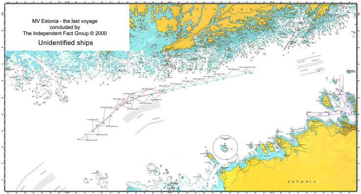
Overview - M/V Estonia - the last voyage
An overview of our conclusion can be seen in the following map. Interesting to note is the fact that both Silja Europe and Mariella had some navigation malfunctions around 23.30, or they had to alter their course by some other unknown reason. The "JAIC course" is also shown for comparison.
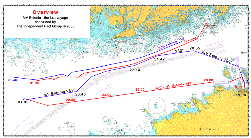
Picture 7. Overview, The Independent Fact Group conclusion.
The unidentified ships versus M/V Estonia
The Finnish printout of "all passenger traffic" 27.09.94 called 'Estonia' 1758 40H.
The following picture has after the accident been the official printout, the log, of M/V Estonia's last route. To our knowledge this log has never been analyzed by JAIC. As seen it is not an printout of the M/V Estonia route, but an printout of the "passenger ship fleet", consequently it contains log information for more than one ship. Our analyze of the content has shown that the logs represent three ships where only one single log can refer from M/V Estonia. The other two ships are unidentified, confirmed by our analyze not to be anyone of the known ships in the Gulf of Finland this night. It is not possible to conclude the single log no. 5 as being from Estonia only from this "printout". Our conclusion that no. 5 originates from M/V Estonia is a result from putting together and analyzing all material presented in this report.
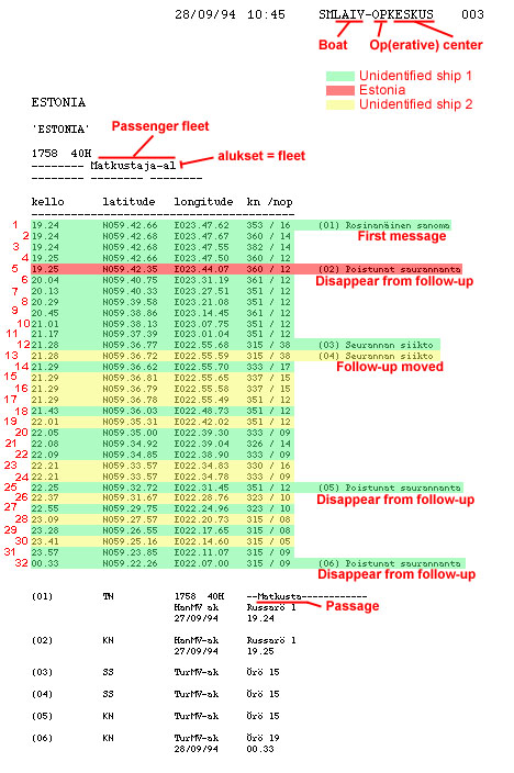
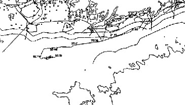
Picture 8. Printout of the Finnish "Estonia log."
In the left of the picture we have noted the logs from 1 to 32 in red. Those can be found on our plot (picture 10). All notes and areas in color has been added by us. The logs no. 1 - 4 are most likely to be from the same ship as the distance between them only are about 100 - 200 meters at "the same time". The log no. 5 can not be from the same ship as no. 1 - 4 as it in such case have had a speed of not under 36 knots. The follow-up of no. 5 is noted to have been lost (from Russarö, see also note at the bottom of the picture). Later the follow-up is moved to "Örö", no. 12 and 13, where the radar cover two ships. The follow-up is again lost, no. 25, for one of the ships, but it seem as the tracking has continued 30 minutes later, no. 27.
We have also analyzed a digitized printout for "Estonia" in the same way as described in the examples above (picture 2 and 5) with the result that this "Estonia-plot" correspond perfectly with the unidentified ships from the log in picture 8. However, as it is named "Estonia" with the same reference "1758" as the log in picture 8, the Finnish Coastal Surveillance must have had a reason believing this to be the Estonia plot.
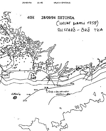
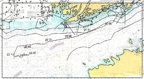
Picture 9. Digitized printout for "Estonia"
In this picture 9 named "ESTONIA" we can se a handwriting "MEVAT MAALI 1758". "MEVAT" is the Finnish short name for "sea surveillance information system" (merivalvonnan tietojörjestelmä), and "MAALI" is the target, i.e. the ship in question. Every ship get a reference number, in this case it is 1758 (the Universal Coordinated Time for the ship entering in to the radar surveillance sector). Entering such sector does not automatically result in plotting the ship, at the time in 1994 mainly because it took a lot of computer memory. It was only when a ship came into a closer coastal range that it was plotted. It was still possible to follow each ship on the radar as they were identified with a reference number.
In the picture we can also read a note "SVO" and a text in Finnish that we have not fully been able to interpret. The word "seurannan" meaning "follow-up" can be seen together with "vastesenotto[?]", vasta meaning in the beginning/earliest. It may describe "loss of tracking" or "beginning/change" maybe to a "new ship". The position correspond with no. 12 and 13 in picture 8 where it refers to "follow-up moved". After that point we can follow two ships very close to each other for a while.
At this time in 1994, it was not possible to identify single ships from the automatic radar surveillance. All ships were at to be manually identified, either afterwards as a reconstruction of the events, or during the night by contacting any ship for identification. As all the ships besides the two unidentified ones described here and M/V Estonia have been successfully traced, it is understandable if the unidentified ships have been mistaken for M/V Estonia, especially if they really were unknown. See also the GGE interview (204 K) from 1998.
UTC versus Local Time
According to our information and what we have found in other logs, the use of Coordinated Universal Time (UTC) is standard for time reference. When graphic plots are produced, as those in the examples above, local time can be used for practical reasons. Following such procedure the logs in picture 8 should refer to UTC. In the printout for "Estonia", picture 9, the time reference however correspond with those in picture 8, way we believe the UTC time reference has been used in this specific printout It means that the local Estonian time is +2 hours.
The Fact Group plot of the "Unidentified ships"
The picture below is an overview of the "Unidentified ships" with a single log from M/V Estonia (no. 5). A close-up of the plot (picture 10) can be opened in a separate window here (155 K). Every single log, 1 - 32 from picture 8 can be found in the close-up with relevant speed information. The two unidentified ships are heading out of the Gulf of Finland, i.e. towards the left in the pictures.
Picture 10. Overview unidentified ships.
Non of the two unidentified ships can be M/V Estonia. The ships are to slow irrespective of the use of UTC or Local Estonian time. Either they are not close enough to reach the place of the disaster, or they can not have been at the beginning of the plot at that time, if they had left Tallinn at 19.00 local time.
With reference to UTC the single log no. 5, at 19.25 is the same as local time 21.25. This report will prove that the single log will fit the M/V Estonia's last route perfectly in relation to other known information and UTC.
Both JAIC and GGE found two unidentified ships on the scene of the accident. It is likely to believe that they are the same ships that follow close to the M/V Estonia route, and slow down at the time of the disaster. Following a clip from" JAIC picture 17.1" and "GGE pg426map" with the two unidentified ships marked.
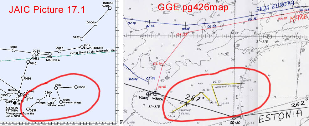
Picture 11. The unidentified ships on the scene of the disaster, part of pictures from JAIC and GGE
The last M/V Estonia voyage
To be able to come to a conclusion regarding the route this last voyage, a number of facts has to fit in the scenario. The facts that we know of, and that we regard as reliable are presented here as input values for the route. The input values can also be found on the detailed plot that can be opened in a separate window here (1032 K).
Input values for the route (in Estonian time)
At 19.00 - Witnesses: Departure. (see list above)
Comment: Without any doubt the departure must have been
19.00 not later than + 5 minutes. Maneuver in the port to turn
the ship could add 10 minutes. Estonia leaves the harbor area
latest 19.15.
At [around 20.00] - Crew: "When we came out in open sea,
a strong wind from the left side started to blew".
(Einar Kuuk, SHK Estonia D 34:85)
Comment: Supports the north exit. If Estonia had left the
south west exit she had gone almost straight in to the wind.
At 21.00 - 21.30 - Witness - saw that the course was 262°.
(Anders Ericson, SHK Estonia G 118)
Comment: The witness is referring to Swedish time, it has
not been noted by JAIC or GGE.
After 21.00 - Crew: "After 21.00 both captains entered
the bridge. We had been on the route towards the way point for
20 minutes" (Einar Kuuk, SHK Estonia D 34:85)
Comment: If they had been on this route for 20 minutes
after 21.00, there must have been a way point after 20.40. According
to JAIC this way point should have been around 20.00. The JAIC
route is incorrect.
At 21.25 - Log for M/V Estonia at N 59.42.35 - E 23.44.07
Comment: See above and picture 8.
At [between 21.00 and 22.00] - Witness - saw Mariella as close
that he could read the ship name. (Rolf Sörman, see below)
Comment: It was dark and the illuminated yellow name on
high side of the superstructure was seen and read. It would not
have been able to read that on a distance longer that approx.
800 meters.
At 22.00 [just after 22.00] - Crew on Mariella: "When
I started my duty at 22.00 I saw M/V Estonia diagonally in front
of us, about 30 degrees on the port side. I saw M/V Silja Europe
further ahead of us on the starboard side." (Ingmar Eklund,
SHK Estonia D 12)
Comment: This information set the position for all three
ships relatively to each other at that time. There is only one
position for each ship that fit as all three ships had different
speed. The witness says he saw her, i.e. visually. Later he refers
to that he "saw her all night on the radar", understandable
as M/V Estonia was faster and ahead of Mariella.
After 22.00 - Crew on Mariella: "During the voyage M/V
Estonia was faster than us" and "Her course at 22.00
was almost westerly" and " I saw M/V Estonia all night
on the radar. The radar was set at 15 nautical miles." (Ingmar
Eklund, SHK Estonia D 12)
Comment: If M/V Estonia had used the JAIC route, she had
been more than 15 nautical miles away, or just targeted that distance.
If that had been the case, the witness had not been able to identify
her as being M/V Estonia.
At 23.00 [around 23.00] - Crew: "Captain was on the bridge
20-30 minutes before the way point, could have been at 23.00.
He left the bridge and we changed the course, and after that we
activated the stabilizers. But there were no waves from the side,
all came from the front." (Einar Kuuk, SHK Estonia D 34:89)
Comment: The turning at the way point that is referred
to here is sometime after 23.00, probably around 23.20 to 23.30.
But more interesting is that after the waypoint, the waves came
from the front. They were heading straight in to the waves. According
to the JAIC route, they should have had waves from the port side
(bow sea) after the way point, a necessity for breaking the visor
loose. The JAIC route is incorrect.
Around 23.00 - Crew: "Around 23.00, before the change
of the course to the west, a big wave hit the left bow side."
(Einar Kuuk, SHK Estonia D 34:85)
Comment: This statement is interesting in two aspects.
First it states that the change of course was "to the west".
It means that they must have been on a south or north course,
changing to west. According to the JAIC route, they already were
on an almost westerly course when they came to the way point.
The JAIC route is incorrect. Secondly, it states that before the
change of course," a big wave hit the left bow side".
How could it? Either they were on the JAIC route or on the one
we have concluded, the wave should have hit the right bow side.
Is this the fatal point of the journey where the ship started
to take in water? A number of witnesses have stated a big "shake"
at around this time.
At 23.30 - Crew: "30 minutes thereafter [23.30] captain
Andresson entered the bridge and stayed for 15 minutes and went
away 15 minutes before the course was changed." (Einar Kuuk,
SHK Estonia D 34:85)
Comment: The change of course is mentioned to have been
after 23.30 close to 24.00, but the reference in time is a bit
unsure.
At 24.00 - Crew: "At the change of course 24.00, the stabilizers
were activated." (Einar Kuuk, SHK Estonia D 34:85)
Comment: The last information regarding the change of course.
In summary the change of course most likely must have been between
23.30 and 24.00. The JAIC route suggests a change at the waypoint
at 00.30. The JAIC route is incorrect.
The Fact Group Conclusion on the last M/V Estonia voyage
Our detailed plot of M/V Estonia's last voyage, including Silja Europe and Mariella can be opened in a separate window here (1032 K). This plot includes the JAIC route.
Our detailed plot of all the ships analyzed in this report can be opened in a separate window here (905 K).
M/V Estonia departed on time at 19.00, and nothing unnormal was reported in the first and original witness statements, neither from the passengers or from the crew, except from one witness stating that she was faster than normal. Her speed was about 18 knots. The ship left through the north exit where she suffered from hard wind and waves from the port side that caused a list to starboard. The course was 290° and the speed reduced to about 17 knots. At this time of the voyage she rolled quite a lot and it caused problem for the people in the restaurants. She was heading for the traffic zone outside the Porkkala fairway where she should change to a course more against the wind and waves.
At 19.58 (UTC 17.58) she entered in to the Finnish surveillance information system MEVAT, and she consequently got the identification no. 1758. When she reached the west way bound zone at 20.55 she altered the course to 262° and increased the speed to the maximum around 20 knots.
At 21.15 both captains entered the bridge and stayed there for 20 - 30 minutes. At this time they were closing up to Mariella that came down from the north east just ahead of Estonia. At 21.24 she is plotted by MEVAT from Russarö, identified as M/V Estonia. However there are two other unidentified ships very close to each other just behind Estonia at this time. All three ships are therefore identified being the same, M/V Estonia. The tracking is lost at 21.25, and that position is the only one that we have identified as originated from M/V Estonia. The presumed tracking of M/V Estonia continues however, but it is one or both of the unidentified ships that are tracked. They are only keeping a speed of around 13 knots and heading almost the same course as M/V Estonia.
At around 21.30 the passenger Rolf Sörman entered up to the 7 deck with his friends. When he came up from the stairway at deck 7 he passed the hall to the opposite side from the stairway diagonally to the left. He was subsequently heading toward the stern with the starboard side on his left. When they stood there, inside the hall, he saw, and read the illuminated name "MARIELLA" in yellowish color through the doors on his left side. As it was very dark outside he could not see which way the ships were heading, and he did believe he saw the ship on the port side of Estonia, and it looked as if Mariella was almost still. This can be explained by a slight alternation of the M/V Estonia course toward the south at 21.42 giving that visual effect.
At around 21.45 M/V Estonia was heading almost parallel with Mariella and Silja Europa.
At 22.14 she was in the position to be seen by Ingmar Eklund, mate on Mariella, 30° on her port side in the same time as Silja Europa is a bit further forward on Mariella's starboard side.
At around 22.50 M/V Estonia enters the point where she follow the traffic zone towards the south west. At around 23.10 she has changed the course to 226° following the zone. This is a necessary change of the course to avoid risk of collision with the fleet coming from Stockholm and heading for the east bound traffic zone in to the Gulf of Finland. On the way from Stockholm to Helsingfors this night were M/V Isabella and Silja Symphony.
At 23.40, after about 30 minutes on this course the last way point was reached, where M/V Estonia changed course to west, or more exactly to 261° heading straight on to Sandhamn and "Revensgrundet". Now she was heading straight in to the waves again and according to Einar Kuuk the stabilizers were activated and the speed decreased with 1 knot.
At 01.02 M/V Estonia suffers from the final damage and shortly thereafter she is lost.
The sinking process, the last turn to starboard, the drifting and the rescue operation will be presented in a separate report.
DEDICATION
We dedicate this report to all those who lost their lives at sea as a result of a ships lack of seaworthiness.
If M/V Estonia had been seaworthy many of the more than 850 persons who lost their lives would have had a chance to survive.
Stockholm 11 February 2001